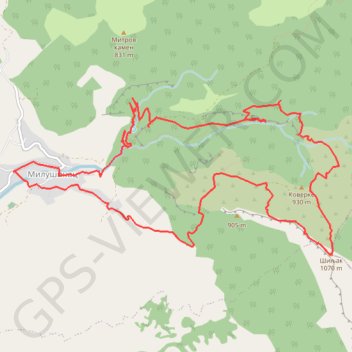
Krstatac: od sela Milušinac, Crnobarski potok, prerast Bogov...
- Distance: 8.8 mi
- Elevation gain: 765 m
- Maximum elevation: 1,055 m
- Elevation loss: 766 m
- Minimum elevation: 446 m
- Moving time: 5 h 4 m
- Moving speed: 1.7 mph
- Maximum speed: 5.2 mph
- Total time: 6 h 24 m
- Global speed: 1.4 mph
Interactive trail map
Trail profile
- Distance: 8.8 mi
- Elevation gain: 765 m
- Maximum elevation: 1,055 m
- Elevation loss: 766 m
- Minimum elevation: 446 m
- Moving time: 5 h 4 m
- Moving speed: 1.7 mph
- Maximum speed: 5.2 mph
- Total time: 6 h 24 m
- Global speed: 1.4 mph
About this trail
Name: Krstatac: od sela Milušinac, Crnobarski potok, prerast Bogov... trail, distance, elevation, map, profile, GPS track
Coordinates: 43.66204 22.01061 43.67725 22.05432
Other hiking, mountain biking, running and outdoor activity trails
Click on a trail to view its statistics, map and profile.
2022_Yu
Slovenia > Ajdovščina > Žapuže
Distance: 1,526.9 mi • Elevation gain: 32,048 m • Maximum elevation: 1,950 m
4-45-2 Milusinac-Krstatac-Bogova vrata
Serbia > Central Serbia > Zajecar Administrative District > Sokobanja Municipality > Milusinac
12.99 km
Distance: 8.1 mi • Elevation gain: 693 m • Maximum elevation: 1,055 m