Make a donation
Gear up for your next adventure:
As an Amazon Associate, this site earns from qualifying purchases at no extra cost to you.
Nonpunglipancarpaniisan
Parcours créé sur Trace de Trail
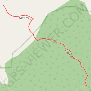
- Distance: 0.3 mi
- Elevation gain: 65 m
- Maximum elevation: 634 m
- Elevation loss: 15 m
- Minimum elevation: 568 m
- Moving time: 3 m 24 s
- Moving speed: 5.1 mph
- Maximum speed: 10.5 mph
- Total time: 3 m 24 s
- Global speed: 5.1 mph
Interactive trail map
Make a donation
Gear up for your next adventure:
As an Amazon Associate, this site earns from qualifying purchases at no extra cost to you.
Trail profile
- Distance: 0.3 mi
- Elevation gain: 65 m
- Maximum elevation: 634 m
- Elevation loss: 15 m
- Minimum elevation: 568 m
- Moving time: 3 m 24 s
- Moving speed: 5.1 mph
- Maximum speed: 10.5 mph
- Total time: 3 m 24 s
- Global speed: 5.1 mph
Make a donation
Gear up for your next adventure:
As an Amazon Associate, this site earns from qualifying purchases at no extra cost to you.
About this trail
Name: Nonpunglipancarpaniisan trail, distance, elevation, map, profile, GPS track
Start: Bypass ArN 1, Babakan Madang, Bogor, West Java, Java, Indonesia (-6.59335 106.91631)
End: Bypass arn 2, Babakan Madang, Bogor, West Java, Java, Indonesia (-6.59559 106.91860)
Coordinates: -6.59561 106.91631 -6.59335 106.91870
Make a donation
Gear up for your next adventure:
As an Amazon Associate, this site earns from qualifying purchases at no extra cost to you.
Other hiking, mountain biking, running and outdoor activity trails
Click on a trail to view its statistics, map and profile.
Ciputat Market to Penginapan Pondok Indah Karang Potong
Indonesia > Banten > South Tangerang
Distance: 172.2 mi • Elevation gain: 4,960 m • Maximum elevation: 790 m