Penosha Loop Trail in Brighton State Recreation Area
The Penosha Loop Trail offers a peaceful and immersive hike through a mix of hardwood forests, scenic meadows, and ridges with glimpses of nearby lakes such as Bishop Lake. This five-mile loop is moderately challenging, with gentle slopes that provide both a good workout and moments for taking in the beauty of the natural surroundings. Wildlife sightings are common, and the trail is especially beautiful in fall when the foliage transforms, creating a rich tapestry of colors along the wooded path. #Hiking #Loop #Lake #Forest #Nature
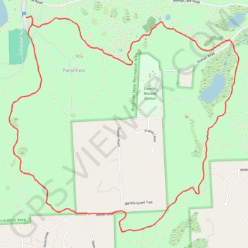
- Distance: 4.9 mi
- Elevation gain: 92 m
- Maximum elevation: 317 m
- Elevation loss: 92 m
- Minimum elevation: 269 m
- Moving time: 1 h 57 m
- Moving speed: 2.5 mph
- Maximum speed: 3.9 mph
- Total time: 2 h 10 m
- Global speed: 2.2 mph
Interactive trail map
Trail profile
- Distance: 4.9 mi
- Elevation gain: 92 m
- Maximum elevation: 317 m
- Elevation loss: 92 m
- Minimum elevation: 269 m
- Moving time: 1 h 57 m
- Moving speed: 2.5 mph
- Maximum speed: 3.9 mph
- Total time: 2 h 10 m
- Global speed: 2.2 mph
About this trail
Name: Penosha Loop Trail in Brighton State Recreation Area trail, distance, elevation, map, profile, GPS track
Coordinates: 42.48402 -83.83680 42.50093 -83.81242