Hafod Garrerog
- Distance: 1.5 mi
- Elevation gain: 55 m
- Maximum elevation: 43 m
- Elevation loss: 55 m
- Minimum elevation: 2 m
- Moving time: 49 m 22 s
- Moving speed: 1.8 mph
- Maximum speed: 3.5 mph
- Total time: 1 h 2 m
- Global speed: 1.4 mph
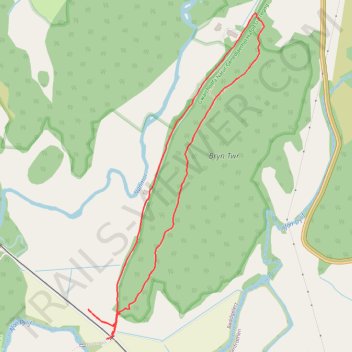
Interactive trail map
Trail profile
- Distance: 1.5 mi
- Elevation gain: 55 m
- Maximum elevation: 43 m
- Elevation loss: 55 m
- Minimum elevation: 2 m
- Moving time: 49 m 22 s
- Moving speed: 1.8 mph
- Maximum speed: 3.5 mph
- Total time: 1 h 2 m
- Global speed: 1.4 mph
About this trail
Name: Hafod Garrerog trail, distance, elevation, map, profile, GPS track
Start: Beddgelert, Gwynedd, Wales, United Kingdom (52.97134 -4.08460)
End: Beddgelert, Gwynedd, Wales, United Kingdom (52.97131 -4.08458)
Coordinates: 52.97070 -4.08589 52.97874 -4.07868
Topography: Gwynedd topographic map, elevation, terrain
Other hiking, mountain biking, running and outdoor activity trails
Click on a trail to view its statistics, map and profile.
Ultra-Trail Snowdonia Eryri UTS 100M
United Kingdom > Wales > Gwynedd > Llanberis
Distance: 101.4 mi • Elevation gain: 9,704 m • Maximum elevation: 1,058 m