Thank you for supporting this site ❤️
Make a donation
Make a donation
Gear up for your next adventure:
As an Amazon Associate, this site earns from qualifying purchases at no extra cost to you.
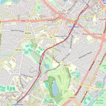
Birmingham Canal path walk to University
- Distance: 2.3 mi
- Elevation gain: 41 m
- Maximum elevation: 154 m
- Elevation loss: 38 m
- Minimum elevation: 137 m
- Moving time: 35 m 31 s
- Moving speed: 3.8 mph
- Maximum speed: 9.3 mph
- Total time: 35 m 31 s
- Global speed: 3.8 mph
Interactive trail map
Thank you for supporting this site ❤️
Make a donation
Make a donation
Gear up for your next adventure:
As an Amazon Associate, this site earns from qualifying purchases at no extra cost to you.
Trail profile
- Distance: 2.3 mi
- Elevation gain: 41 m
- Maximum elevation: 154 m
- Elevation loss: 38 m
- Minimum elevation: 137 m
- Moving time: 35 m 31 s
- Moving speed: 3.8 mph
- Maximum speed: 9.3 mph
- Total time: 35 m 31 s
- Global speed: 3.8 mph
Thank you for supporting this site ❤️
Make a donation
Make a donation
Gear up for your next adventure:
As an Amazon Associate, this site earns from qualifying purchases at no extra cost to you.
About this trail
Name: Birmingham Canal path walk to University trail, distance, elevation, map, profile, GPS track
Coordinates: 52.45146 -1.93631 52.47610 -1.90728
Topography: Birmingham topographic map, elevation, terrain
Thank you for supporting this site ❤️
Make a donation
Make a donation
Gear up for your next adventure:
As an Amazon Associate, this site earns from qualifying purchases at no extra cost to you.