Thank you for supporting this site ❤️
Make a donation
Make a donation
Gear up for your next adventure:
As an Amazon Associate, this site earns from qualifying purchases at no extra cost to you.
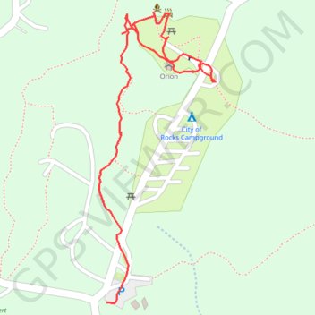
City of Rocks State Park
- Distance: 0.6 mi
- Elevation gain: 26 m
- Maximum elevation: 1,612 m
- Elevation loss: 10 m
- Minimum elevation: 1,594 m
- Moving time: 20 m 17 s
- Moving speed: 1.9 mph
- Maximum speed: 4.4 mph
- Total time: 32 m 25 s
- Global speed: 1.2 mph
Interactive trail map
Thank you for supporting this site ❤️
Make a donation
Make a donation
Gear up for your next adventure:
As an Amazon Associate, this site earns from qualifying purchases at no extra cost to you.
Trail profile
- Distance: 0.6 mi
- Elevation gain: 26 m
- Maximum elevation: 1,612 m
- Elevation loss: 10 m
- Minimum elevation: 1,594 m
- Moving time: 20 m 17 s
- Moving speed: 1.9 mph
- Maximum speed: 4.4 mph
- Total time: 32 m 25 s
- Global speed: 1.2 mph
Thank you for supporting this site ❤️
Make a donation
Make a donation
Gear up for your next adventure:
As an Amazon Associate, this site earns from qualifying purchases at no extra cost to you.
About this trail
Name: City of Rocks State Park trail, distance, elevation, map, profile, GPS track
Start: City of Rocks, Grant County, New Mexico, United States (32.58779 -107.97469)
Coordinates: 32.58778 -107.97481 32.59167 -107.97296
Thank you for supporting this site ❤️
Make a donation
Make a donation
Gear up for your next adventure:
As an Amazon Associate, this site earns from qualifying purchases at no extra cost to you.