Thank you for supporting this site ❤️
Make a donation
Make a donation
Gear up for your next adventure:
As an Amazon Associate, this site earns from qualifying purchases at no extra cost to you.
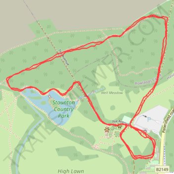
Havant Parkrun
- Distance: 3.1 mi
- Elevation gain: 51 m
- Maximum elevation: 46 m
- Elevation loss: 51 m
- Minimum elevation: 25 m
- Moving time: 31 m 33 s
- Moving speed: 5.9 mph
- Maximum speed: 13.4 mph
- Total time: 31 m 33 s
- Global speed: 5.9 mph
Interactive trail map
Thank you for supporting this site ❤️
Make a donation
Make a donation
Gear up for your next adventure:
As an Amazon Associate, this site earns from qualifying purchases at no extra cost to you.
Trail profile
- Distance: 3.1 mi
- Elevation gain: 51 m
- Maximum elevation: 46 m
- Elevation loss: 51 m
- Minimum elevation: 25 m
- Moving time: 31 m 33 s
- Moving speed: 5.9 mph
- Maximum speed: 13.4 mph
- Total time: 31 m 33 s
- Global speed: 5.9 mph
Thank you for supporting this site ❤️
Make a donation
Make a donation
Gear up for your next adventure:
As an Amazon Associate, this site earns from qualifying purchases at no extra cost to you.
About this trail
Name: Havant Parkrun trail, distance, elevation, map, profile, GPS track
Coordinates: 50.87534 -0.98252 50.88056 -0.97325
Topography: Hampshire topographic map, elevation, terrain
Thank you for supporting this site ❤️
Make a donation
Make a donation
Gear up for your next adventure:
As an Amazon Associate, this site earns from qualifying purchases at no extra cost to you.