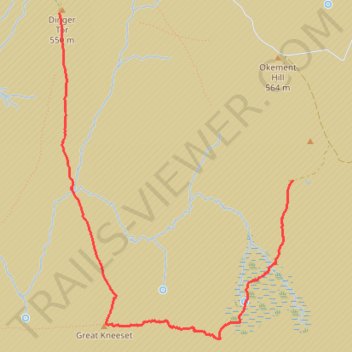
Dinger Tor to Ockerton Court via Great Kneeset
- Distance: 3.0 mi
- Elevation gain: 130 m
- Maximum elevation: 568 m
- Elevation loss: 118 m
- Minimum elevation: 472 m
- Moving time: 1 h 39 m
- Moving speed: 1.8 mph
- Maximum speed: 6.2 mph
- Total time: 2 h 18 m
- Global speed: 1.3 mph
Interactive trail map
Trail profile
- Distance: 3.0 mi
- Elevation gain: 130 m
- Maximum elevation: 568 m
- Elevation loss: 118 m
- Minimum elevation: 472 m
- Moving time: 1 h 39 m
- Moving speed: 1.8 mph
- Maximum speed: 6.2 mph
- Total time: 2 h 18 m
- Global speed: 1.3 mph
About this trail
Name: Dinger Tor to Ockerton Court via Great Kneeset trail, distance, elevation, map, profile, GPS track
End: Okement Hill Road, Dartmoor Forest, West Devon, Devon, England, United Kingdom (50.66454 -3.97877)
Coordinates: 50.65439 -4.00227 50.67519 -3.97878
Topography: West Devon topographic map, elevation, terrain