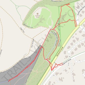
Hansen Dam
- Distance: 1.6 mi
- Elevation gain: 50 m
- Maximum elevation: 344 m
- Elevation loss: 50 m
- Minimum elevation: 312 m
- Moving time: 37 m 9 s
- Moving speed: 2.7 mph
- Maximum speed: 4.6 mph
- Total time: 41 m 43 s
- Global speed: 2.4 mph
Interactive trail map
Trail profile
- Distance: 1.6 mi
- Elevation gain: 50 m
- Maximum elevation: 344 m
- Elevation loss: 50 m
- Minimum elevation: 312 m
- Moving time: 37 m 9 s
- Moving speed: 2.7 mph
- Maximum speed: 4.6 mph
- Total time: 41 m 43 s
- Global speed: 2.4 mph
About this trail
Name: Hansen Dam trail, distance, elevation, map, profile, GPS track
Coordinates: 34.25988 -118.37436 34.26550 -118.36844
Other hiking, mountain biking, running and outdoor activity trails
Click on a trail to view its statistics, map and profile.
Hansen Dam East
United States > California > Los Angeles County > Los Angeles
Distance: 2.9 mi • Elevation gain: 59 m • Maximum elevation: 332 m