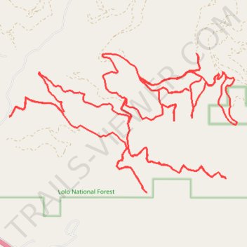
Black cat gulch
- Distance: 25.2 mi
- Elevation gain: 1,327 m
- Maximum elevation: 1,714 m
- Elevation loss: 1,328 m
- Minimum elevation: 992 m
- Moving time: 3 h 49 m
- Moving speed: 6.6 mph
- Maximum speed: 30.6 mph
- Total time: 4 h 43 m
- Global speed: 5.3 mph
Interactive trail map
Trail profile
- Distance: 25.2 mi
- Elevation gain: 1,327 m
- Maximum elevation: 1,714 m
- Elevation loss: 1,328 m
- Minimum elevation: 992 m
- Moving time: 3 h 49 m
- Moving speed: 6.6 mph
- Maximum speed: 30.6 mph
- Total time: 4 h 43 m
- Global speed: 5.3 mph
About this trail
Name: Black cat gulch trail, distance, elevation, map, profile, GPS track
Start: Black Cat Gulch Road, Missoula County, Montana, United States (47.02392 -114.19692)
End: Black Cat Gulch Road, Missoula County, Montana, United States (47.02390 -114.19695)
Coordinates: 47.00894 -114.19695 47.03629 -114.13174