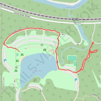
Park Lake
- Distance: 1.1 mi
- Elevation gain: 21 m
- Maximum elevation: 330 m
- Elevation loss: 20 m
- Minimum elevation: 318 m
- Moving time: 27 m 38 s
- Moving speed: 2.4 mph
- Maximum speed: 3.7 mph
- Total time: 30 m
- Global speed: 2.2 mph
Interactive trail map
Trail profile
- Distance: 1.1 mi
- Elevation gain: 21 m
- Maximum elevation: 330 m
- Elevation loss: 20 m
- Minimum elevation: 318 m
- Moving time: 27 m 38 s
- Moving speed: 2.4 mph
- Maximum speed: 3.7 mph
- Total time: 30 m
- Global speed: 2.2 mph
About this trail
Name: Park Lake trail, distance, elevation, map, profile, GPS track
Start: Firefly Trail, Munroe Falls, Summit County, Ohio, 44262, United States (41.13119 -81.41985)
End: South River Road, Munroe Falls, Summit County, Ohio, 44262, United States (41.13263 -81.42532)
Coordinates: 41.13113 -81.42675 41.13429 -81.41803
Other hiking, mountain biking, running and outdoor activity trails
Click on a trail to view its statistics, map and profile.
Lions Club Park to Franklin Mills Riveredge Park via Freedom Trail and Portage Hike & Bike Trail
United States > Ohio > Summit County > Tallmadge
Distance: 11.6 mi • Elevation gain: 138 m • Maximum elevation: 350 m