Thank you for supporting this site ❤️
Make a donation
Make a donation
Gear up for your next adventure:
As an Amazon Associate, this site earns from qualifying purchases at no extra cost to you.
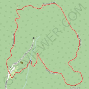
Hike on Cardwell Mountain (Apple Brandy Trail)
Apple Brandy Trail
- Distance: 2.5 mi
- Elevation gain: 114 m
- Maximum elevation: 408 m
- Elevation loss: 114 m
- Minimum elevation: 300 m
- Moving time: 55 m 42 s
- Moving speed: 2.7 mph
- Maximum speed: 4.7 mph
- Total time: 1 h 2 m
- Global speed: 2.4 mph
Interactive trail map
Thank you for supporting this site ❤️
Make a donation
Make a donation
Gear up for your next adventure:
As an Amazon Associate, this site earns from qualifying purchases at no extra cost to you.
Trail profile
- Distance: 2.5 mi
- Elevation gain: 114 m
- Maximum elevation: 408 m
- Elevation loss: 114 m
- Minimum elevation: 300 m
- Moving time: 55 m 42 s
- Moving speed: 2.7 mph
- Maximum speed: 4.7 mph
- Total time: 1 h 2 m
- Global speed: 2.4 mph
Thank you for supporting this site ❤️
Make a donation
Make a donation
Gear up for your next adventure:
As an Amazon Associate, this site earns from qualifying purchases at no extra cost to you.
About this trail
Name: Hike on Cardwell Mountain (Apple Brandy Trail) trail, distance, elevation, map, profile, GPS track
Coordinates: 35.66404 -85.68461 35.67269 -85.67475
Thank you for supporting this site ❤️
Make a donation
Make a donation
Gear up for your next adventure:
As an Amazon Associate, this site earns from qualifying purchases at no extra cost to you.
Other hiking, mountain biking, running and outdoor activity trails
Click on a trail to view its statistics, map and profile.
Gmaps Pedometer Route
United States > Kentucky > Fulton County > Hickman
Distance: 312.5 mi • Elevation gain: 4,204 m • Maximum elevation: 592 m