Thank you for supporting this site ❤️
Make a donation
Make a donation
Gear up for your next adventure:
As an Amazon Associate, this site earns from qualifying purchases at no extra cost to you.
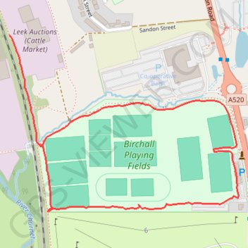
New path around Birchall playing fields
- Distance: 1.1 mi
- Elevation gain: 15 m
- Maximum elevation: 157 m
- Elevation loss: 16 m
- Minimum elevation: 144 m
- Moving time: 24 m 57 s
- Moving speed: 2.6 mph
- Maximum speed: 3.8 mph
- Total time: 25 m 25 s
- Global speed: 2.5 mph
Interactive trail map
Thank you for supporting this site ❤️
Make a donation
Make a donation
Gear up for your next adventure:
As an Amazon Associate, this site earns from qualifying purchases at no extra cost to you.
Trail profile
- Distance: 1.1 mi
- Elevation gain: 15 m
- Maximum elevation: 157 m
- Elevation loss: 16 m
- Minimum elevation: 144 m
- Moving time: 24 m 57 s
- Moving speed: 2.6 mph
- Maximum speed: 3.8 mph
- Total time: 25 m 25 s
- Global speed: 2.5 mph
Thank you for supporting this site ❤️
Make a donation
Make a donation
Gear up for your next adventure:
As an Amazon Associate, this site earns from qualifying purchases at no extra cost to you.
About this trail
Name: New path around Birchall playing fields trail, distance, elevation, map, profile, GPS track
Coordinates: 53.09261 -2.03011 53.09632 -2.02206
Topography: Staffordshire Moorlands topographic map, elevation, terrain
Thank you for supporting this site ❤️
Make a donation
Make a donation
Gear up for your next adventure:
As an Amazon Associate, this site earns from qualifying purchases at no extra cost to you.