Zla kolata-Dobra kolata
- Distance: 14.1 mi
- Elevation gain: 1,659 m
- Maximum elevation: 2,508 m
- Elevation loss: 1,751 m
- Minimum elevation: 928 m
- Moving time: 8 h 11 m
- Moving speed: 1.7 mph
- Maximum speed: 6.7 mph
- Total time: 12 h 34 m
- Global speed: 1.1 mph
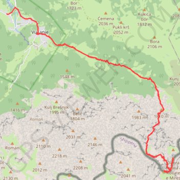
Interactive trail map
Trail profile
- Distance: 14.1 mi
- Elevation gain: 1,659 m
- Maximum elevation: 2,508 m
- Elevation loss: 1,751 m
- Minimum elevation: 928 m
- Moving time: 8 h 11 m
- Moving speed: 1.7 mph
- Maximum speed: 6.7 mph
- Total time: 12 h 34 m
- Global speed: 1.1 mph
About this trail
Name: Zla kolata-Dobra kolata trail, distance, elevation, map, profile, GPS track
Start: Zarunice, Vusanje, Gusinje Municipality, 84326, Montenegro (42.52570 19.84479)
Coordinates: 42.48454 19.83263 42.53365 19.89992
Other hiking, mountain biking, running and outdoor activity trails
Click on a trail to view its statistics, map and profile.
2022_Yu
Slovenia > Ajdovščina > Žapuže
Distance: 1,526.9 mi • Elevation gain: 32,048 m • Maximum elevation: 1,950 m