New
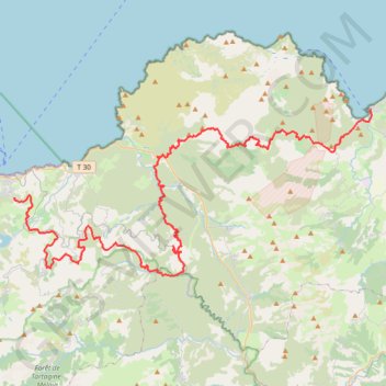
- Distance: 49.9 mi
- Elevation gain: 2,000 m
- Maximum elevation: 692 m
- Elevation loss: 1,786 m
- Minimum elevation: -3 m
Interactive trail map
Trail profile
- Distance: 49.9 mi
- Elevation gain: 2,000 m
- Maximum elevation: 692 m
- Elevation loss: 1,786 m
- Minimum elevation: -3 m
About this trail
Name: New trail, distance, elevation, map, profile, GPS track
Coordinates: 42.56078 8.95503 42.68054 9.30306
Other hiking, mountain biking, running and outdoor activity trails
Click on a trail to view its statistics, map and profile.
1 LUCENA - MONTPELLIER
Distance: 1,842.0 mi • Elevation gain: 29,500 m • Maximum elevation: 1,048 m
New
France > Corsica > Haute-Corse > Saint-Florent
Distance: 31.0 mi • Elevation gain: 1,078 m • Maximum elevation: 369 m
New
France > Corsica > Haute-Corse > Monticello
Distance: 25.0 mi • Elevation gain: 837 m • Maximum elevation: 536 m
New
France > Corsica > Haute-Corse > Monticello
Distance: 31.0 mi • Elevation gain: 1,023 m • Maximum elevation: 536 m