Thank you for supporting this site ❤️
Make a donation
Make a donation
Gear up for your next adventure:
As an Amazon Associate, this site earns from qualifying purchases at no extra cost to you.
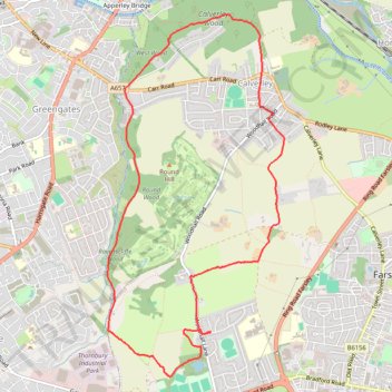
Calverley Loop Walk
- Distance: 5.7 mi
- Elevation gain: 157 m
- Maximum elevation: 202 m
- Elevation loss: 157 m
- Minimum elevation: 97 m
- Moving time: 1 h 59 m
- Moving speed: 2.8 mph
- Maximum speed: 12.1 mph
- Total time: 2 h 24 m
- Global speed: 2.4 mph
Interactive trail map
Thank you for supporting this site ❤️
Make a donation
Make a donation
Gear up for your next adventure:
As an Amazon Associate, this site earns from qualifying purchases at no extra cost to you.
Trail profile
- Distance: 5.7 mi
- Elevation gain: 157 m
- Maximum elevation: 202 m
- Elevation loss: 157 m
- Minimum elevation: 97 m
- Moving time: 1 h 59 m
- Moving speed: 2.8 mph
- Maximum speed: 12.1 mph
- Total time: 2 h 24 m
- Global speed: 2.4 mph
Thank you for supporting this site ❤️
Make a donation
Make a donation
Gear up for your next adventure:
As an Amazon Associate, this site earns from qualifying purchases at no extra cost to you.
About this trail
Name: Calverley Loop Walk trail, distance, elevation, map, profile, GPS track
Start: The Knoll, Thornbury, Farsley, West Yorkshire, England, LS28 5FB, United Kingdom (53.80981 -1.69368)
Coordinates: 53.80619 -1.70769 53.83506 -1.68380
Topography: England topographic map, elevation, terrain
Thank you for supporting this site ❤️
Make a donation
Make a donation
Gear up for your next adventure:
As an Amazon Associate, this site earns from qualifying purchases at no extra cost to you.