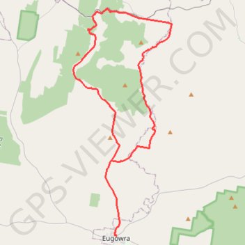
Eugowra - House of Commons Mountain loop
- Distance: 40.7 mi
- Elevation gain: 754 m
- Maximum elevation: 524 m
- Elevation loss: 756 m
- Minimum elevation: 271 m
- Moving time: 3 h 32 m
- Moving speed: 11.5 mph
- Maximum speed: 26.2 mph
- Total time: 3 h 32 m
- Global speed: 11.5 mph
Interactive trail map
Trail profile
- Distance: 40.7 mi
- Elevation gain: 754 m
- Maximum elevation: 524 m
- Elevation loss: 756 m
- Minimum elevation: 271 m
- Moving time: 3 h 32 m
- Moving speed: 11.5 mph
- Maximum speed: 26.2 mph
- Total time: 3 h 32 m
- Global speed: 11.5 mph
About this trail
Name: Eugowra - House of Commons Mountain loop trail, distance, elevation, map, profile, GPS track
Start: Pye Street, Eugowra, Cabonne Council, New South Wales, 2806, Australia (-33.42717 148.37145)
End: North Street, Eugowra, Cabonne Council, New South Wales, 2806, Australia (-33.42559 148.36954)
Coordinates: -33.42717 148.32372 -33.21696 148.43247
Other hiking, mountain biking, running and outdoor activity trails
Click on a trail to view its statistics, map and profile.
Cookamidgera - House of Commons Mountain loop
Australia > New South Wales > Cookamidgera
Distance: 39.9 mi • Elevation gain: 703 m • Maximum elevation: 532 m