Make a donation
Gear up for your next adventure:
As an Amazon Associate, this site earns from qualifying purchases at no extra cost to you.
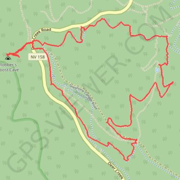
Spring Mountains - Robbers Roost Cave, Telephone Canyon Road, Trough Trail, Showgirl Trail Loop
- Distance: 4.3 mi
- Elevation gain: 392 m
- Maximum elevation: 2,505 m
- Elevation loss: 392 m
- Minimum elevation: 2,254 m
- Moving time: 2 h 4 m
- Moving speed: 2.1 mph
- Maximum speed: 3.0 mph
- Total time: 2 h 42 m
- Global speed: 1.6 mph
Interactive trail map
Make a donation
Gear up for your next adventure:
As an Amazon Associate, this site earns from qualifying purchases at no extra cost to you.
Trail profile
- Distance: 4.3 mi
- Elevation gain: 392 m
- Maximum elevation: 2,505 m
- Elevation loss: 392 m
- Minimum elevation: 2,254 m
- Moving time: 2 h 4 m
- Moving speed: 2.1 mph
- Maximum speed: 3.0 mph
- Total time: 2 h 42 m
- Global speed: 1.6 mph
Make a donation
Gear up for your next adventure:
As an Amazon Associate, this site earns from qualifying purchases at no extra cost to you.
About this trail
Name: Spring Mountains - Robbers Roost Cave, Telephone Canyon Road, Trough Trail, Showgirl Trail Loop trail, distance, elevation, map, profile, GPS track
Start: Deer Creek Road, Mount Charleston, Clark County, Nevada, United States (36.30404 -115.60499)
End: Deer Creek Road, Mount Charleston, Clark County, Nevada, United States (36.30403 -115.60489)
Coordinates: 36.29310 -115.61258 36.30472 -115.59567
Make a donation
Gear up for your next adventure:
As an Amazon Associate, this site earns from qualifying purchases at no extra cost to you.