Benjaw day 1
- Distance: 215.7 mi
- Elevation gain: 6,365 m
- Maximum elevation: 878 m
- Elevation loss: 6,362 m
- Minimum elevation: -1 m
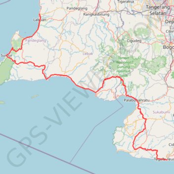
Interactive trail map
Trail profile
- Distance: 215.7 mi
- Elevation gain: 6,365 m
- Maximum elevation: 878 m
- Elevation loss: 6,362 m
- Minimum elevation: -1 m
About this trail
Name: Benjaw day 1 trail, distance, elevation, map, profile, GPS track
Start: 3, Banjarmasin, Pandeglang, Banten, Java, 42264, Indonesia (-6.35331 105.82621)
Coordinates: -7.42900 105.58266 -6.35331 106.77819
Other hiking, mountain biking, running and outdoor activity trails
Click on a trail to view its statistics, map and profile.
BENTANGJAWA2024_FINAL
Indonesia > West Java > Sukabumi > Tegalbuleud > Panaruban
Distance: 712.8 mi • Elevation gain: 12,308 m • Maximum elevation: 2,460 m
BENTANGJAWA2024_FINAL
Indonesia > West Java > Sukabumi > Tegalbuleud > Panaruban
Distance: 266.1 mi • Elevation gain: 3,937 m • Maximum elevation: 279 m
BENTANGJAWA2024_FINAL
Indonesia > West Java > Sukabumi > Tegalbuleud > Panaruban
Distance: 266.1 mi • Elevation gain: 3,937 m • Maximum elevation: 279 m
Ciputat Market to Penginapan Pondok Indah Karang Potong
Indonesia > Banten > South Tangerang
Distance: 172.2 mi • Elevation gain: 4,960 m • Maximum elevation: 790 m