Make a donation
Gear up for your next adventure:
As an Amazon Associate, this site earns from qualifying purchases at no extra cost to you.
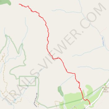
Bear Mountain Trail in Red Rock-Secret Mountain Wilderness
The Bear Mountain Trail in Arizona's Red Rock-Secret Mountain Wilderness offers hikers a challenging ascent through rugged terrain, culminating in panoramic vistas of the surrounding red rock formations, deep canyons, and distant mountain ranges. Along the route, hikers can observe unique geological features such as sandstone arches and pinnacles, as well as diverse vegetation that supports local wildlife. The trail's steep inclines and rocky paths demand physical endurance, but the rewarding views make it a memorable experience for seasoned hikers. #Hiking #Mountain #Rock #Nature #Overlook
- Distance: 4.8 mi
- Elevation gain: 630 m
- Maximum elevation: 1,954 m
- Elevation loss: 630 m
- Minimum elevation: 1,398 m
- Moving time: 3 h 7 m
- Moving speed: 1.5 mph
- Maximum speed: 5.3 mph
- Total time: 3 h 44 m
- Global speed: 1.3 mph
Interactive trail map
Make a donation
Gear up for your next adventure:
As an Amazon Associate, this site earns from qualifying purchases at no extra cost to you.
Trail profile
- Distance: 4.8 mi
- Elevation gain: 630 m
- Maximum elevation: 1,954 m
- Elevation loss: 630 m
- Minimum elevation: 1,398 m
- Moving time: 3 h 7 m
- Moving speed: 1.5 mph
- Maximum speed: 5.3 mph
- Total time: 3 h 44 m
- Global speed: 1.3 mph
Make a donation
Gear up for your next adventure:
As an Amazon Associate, this site earns from qualifying purchases at no extra cost to you.
About this trail
Name: Bear Mountain Trail in Red Rock-Secret Mountain Wilderness trail, distance, elevation, map, profile, GPS track
Coordinates: 34.89344 -111.88345 34.91451 -111.86537
Make a donation
Gear up for your next adventure:
As an Amazon Associate, this site earns from qualifying purchases at no extra cost to you.
Other hiking, mountain biking, running and outdoor activity trails
Click on a trail to view its statistics, map and profile.
Boynton Canyon Trail via Boynton Vista and Boynton Subway in Red Rock-Secret Mountain Wilderness
United States > Arizona > Yavapai County
The Boynton Canyon Trail offers a peaceful journey through shaded forests, towering red rock formations, and sweeping views of the canyon floor. While the trail itself is easy to follow, it features a bit of a climb toward the end, making it a nice mix of challenge and relaxation. For an extra treat, take the…
Distance: 7.9 mi • Elevation gain: 480 m • Maximum elevation: 1,595 m
Bear Mountain Trail in Red Rock-Secret Mountain Wilderness
United States > Arizona > Yavapai County
The Bear Mountain Trail offers a challenging and scenic hike, ideal for experienced hikers looking for stunning views and rugged terrain. As you ascend, you'll be treated to expansive vistas of the Sedona area, with sights of iconic landmarks like Fay Canyon, Wilson Mountain, and the Verde Valley. The…
Distance: 4.6 mi • Elevation gain: 643 m • Maximum elevation: 1,962 m
Make a donation
Gear up for your next adventure:
As an Amazon Associate, this site earns from qualifying purchases at no extra cost to you.