Thank you for supporting this site ❤️
Make a donation
Make a donation
Gear up for your next adventure:
As an Amazon Associate, this site earns from qualifying purchases at no extra cost to you.
Jersey Farm Parkrun
- Distance: 3.2 mi
- Elevation gain: 67 m
- Maximum elevation: 113 m
- Elevation loss: 63 m
- Minimum elevation: 92 m
- Moving time: 31 m 59 s
- Moving speed: 5.9 mph
- Maximum speed: 10.6 mph
- Total time: 31 m 59 s
- Global speed: 5.9 mph
Interactive trail map
Thank you for supporting this site ❤️
Make a donation
Make a donation
Gear up for your next adventure:
As an Amazon Associate, this site earns from qualifying purchases at no extra cost to you.
Trail profile
- Distance: 3.2 mi
- Elevation gain: 67 m
- Maximum elevation: 113 m
- Elevation loss: 63 m
- Minimum elevation: 92 m
- Moving time: 31 m 59 s
- Moving speed: 5.9 mph
- Maximum speed: 10.6 mph
- Total time: 31 m 59 s
- Global speed: 5.9 mph
Thank you for supporting this site ❤️
Make a donation
Make a donation
Gear up for your next adventure:
As an Amazon Associate, this site earns from qualifying purchases at no extra cost to you.
About this trail
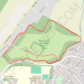
Name: Jersey Farm Parkrun trail, distance, elevation, map, profile, GPS track
Coordinates: 51.77271 -0.31278 51.77692 -0.30067
Topography: St Albans topographic map, elevation, terrain
Thank you for supporting this site ❤️
Make a donation
Make a donation
Gear up for your next adventure:
As an Amazon Associate, this site earns from qualifying purchases at no extra cost to you.