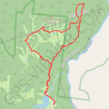
Latimer 5 mile loop
Van Buren County Hiking
- Distance: 5.2 mi
- Elevation gain: 127 m
- Maximum elevation: 542 m
- Elevation loss: 127 m
- Minimum elevation: 508 m
- Moving time: 2 h 53 s
- Moving speed: 2.6 mph
- Maximum speed: 4.2 mph
- Total time: 2 h 31 m
- Global speed: 2.1 mph
Interactive trail map
Trail profile
- Distance: 5.2 mi
- Elevation gain: 127 m
- Maximum elevation: 542 m
- Elevation loss: 127 m
- Minimum elevation: 508 m
- Moving time: 2 h 53 s
- Moving speed: 2.6 mph
- Maximum speed: 4.2 mph
- Total time: 2 h 31 m
- Global speed: 2.1 mph
About this trail
Name: Latimer 5 mile loop trail, distance, elevation, map, profile, GPS track
Start: Plantation Road, Van Buren County, Middle Tennessee, Tennessee, United States (35.79945 -85.28189)
End: Plantation Road, Van Buren County, Middle Tennessee, Tennessee, United States (35.79965 -85.28187)
Coordinates: 35.79945 -85.29011 35.82286 -85.27317