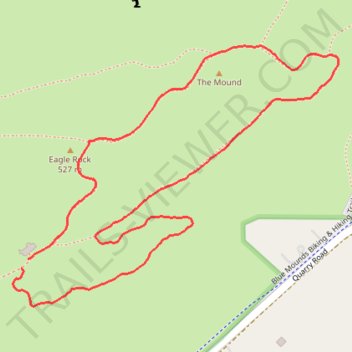
The Mound and Eagle Rock loop hike in Blue Mounds State Park
- Distance: 1.5 mi
- Elevation gain: 49 m
- Maximum elevation: 520 m
- Elevation loss: 46 m
- Minimum elevation: 486 m
- Moving time: 38 m 1 s
- Moving speed: 2.3 mph
- Maximum speed: 3.2 mph
- Total time: 39 m 11 s
- Global speed: 2.3 mph
Interactive trail map
Trail profile
- Distance: 1.5 mi
- Elevation gain: 49 m
- Maximum elevation: 520 m
- Elevation loss: 46 m
- Minimum elevation: 486 m
- Moving time: 38 m 1 s
- Moving speed: 2.3 mph
- Maximum speed: 3.2 mph
- Total time: 39 m 11 s
- Global speed: 2.3 mph
About this trail
Name: The Mound and Eagle Rock loop hike in Blue Mounds State Park trail, distance, elevation, map, profile, GPS track
Start: Park Road, Mound Township, Rock County, Minnesota, 56156, United States (43.69141 -96.19612)
End: Park Road, Mound Township, Rock County, Minnesota, 56156, United States (43.69160 -96.19595)
Coordinates: 43.69072 -96.19634 43.69556 -96.18799