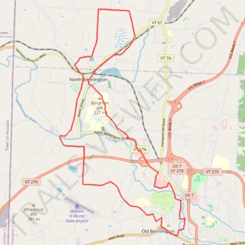
Bicycle loop ride between Bennington and North Bennington
- Distance: 15.1 mi
- Elevation gain: 330 m
- Maximum elevation: 266 m
- Elevation loss: 330 m
- Minimum elevation: 162 m
- Moving time: 1 h 27 m
- Moving speed: 10.4 mph
- Maximum speed: 30.3 mph
- Total time: 1 h 31 m
- Global speed: 9.9 mph
Interactive trail map
Trail profile
- Distance: 15.1 mi
- Elevation gain: 330 m
- Maximum elevation: 266 m
- Elevation loss: 330 m
- Minimum elevation: 162 m
- Moving time: 1 h 27 m
- Moving speed: 10.4 mph
- Maximum speed: 30.3 mph
- Total time: 1 h 31 m
- Global speed: 9.9 mph
About this trail
Name: Bicycle loop ride between Bennington and North Bennington trail, distance, elevation, map, profile, GPS track
Coordinates: 42.88173 -73.25472 42.95213 -73.20163
Other hiking, mountain biking, running and outdoor activity trails
Click on a trail to view its statistics, map and profile.