Thank you for supporting this site ❤️
Make a donation
Make a donation
Gear up for your next adventure:
As an Amazon Associate, this site earns from qualifying purchases at no extra cost to you.
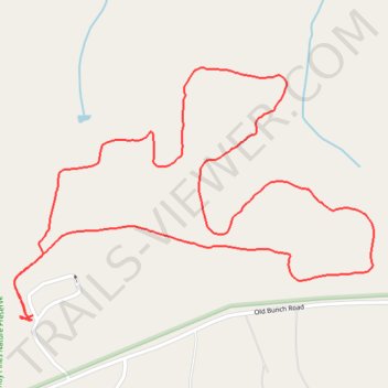
Sandy Pines Nature Preserve - Horseshoe Trail
- Distance: 2.4 mi
- Elevation gain: 22 m
- Maximum elevation: 107 m
- Elevation loss: 21 m
- Minimum elevation: 93 m
- Moving time: 50 m 42 s
- Moving speed: 2.8 mph
- Maximum speed: 3.8 mph
- Total time: 51 m 46 s
- Global speed: 2.8 mph
Interactive trail map
Thank you for supporting this site ❤️
Make a donation
Make a donation
Gear up for your next adventure:
As an Amazon Associate, this site earns from qualifying purchases at no extra cost to you.
Trail profile
- Distance: 2.4 mi
- Elevation gain: 22 m
- Maximum elevation: 107 m
- Elevation loss: 21 m
- Minimum elevation: 93 m
- Moving time: 50 m 42 s
- Moving speed: 2.8 mph
- Maximum speed: 3.8 mph
- Total time: 51 m 46 s
- Global speed: 2.8 mph
Thank you for supporting this site ❤️
Make a donation
Make a donation
Gear up for your next adventure:
As an Amazon Associate, this site earns from qualifying purchases at no extra cost to you.
About this trail
Name: Sandy Pines Nature Preserve - Horseshoe Trail trail, distance, elevation, map, profile, GPS track
Start: Wake County, North Carolina, 27951, United States (35.83238 -78.39102)
End: Wake County, North Carolina, 27951, United States (35.83243 -78.39094)
Coordinates: 35.83231 -78.39148 35.83826 -78.38103
Thank you for supporting this site ❤️
Make a donation
Make a donation
Gear up for your next adventure:
As an Amazon Associate, this site earns from qualifying purchases at no extra cost to you.