Gravesite of The Peddler
- Distance: 4.7 mi
- Elevation gain: 89 m
- Maximum elevation: 99 m
- Elevation loss: 89 m
- Minimum elevation: 13 m
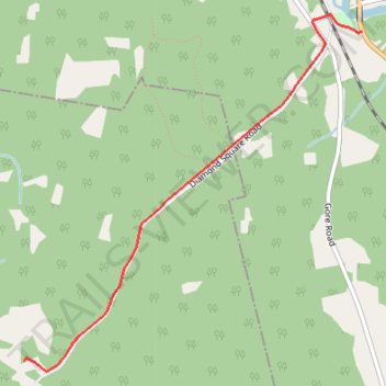
Interactive trail map
Trail profile
- Distance: 4.7 mi
- Elevation gain: 89 m
- Maximum elevation: 99 m
- Elevation loss: 89 m
- Minimum elevation: 13 m
About this trail
Name: Gravesite of The Peddler trail, distance, elevation, map, profile, GPS track
Start: Sunbury Drive, Gladstone Parish, Sunbury County, New Brunswick, E5L 1Y1, Canada (45.65622 -66.60684)
End: Sunbury Drive, Gladstone Parish, Sunbury County, New Brunswick, E5L 1Y1, Canada (45.65622 -66.60684)
Coordinates: 45.63542 -66.63652 45.65730 -66.60684
Other hiking, mountain biking, running and outdoor activity trails
Click on a trail to view its statistics, map and profile.
Upper Kingsclear - Carters Point
Canada > New Brunswick > Kingsclear Parish
Saint John River. #Bike
Distance: 77.8 mi • Elevation gain: 1,030 m • Maximum elevation: 121 m