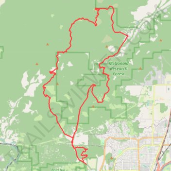
Trails and roads around Dunn Forest
- Distance: 27.1 mi
- Elevation gain: 1,516 m
- Maximum elevation: 571 m
- Elevation loss: 1,516 m
- Minimum elevation: 94 m
- Moving time: 3 h 26 m
- Moving speed: 7.9 mph
- Maximum speed: 40.6 mph
- Total time: 3 h 34 m
- Global speed: 7.6 mph
Interactive trail map
Trail profile
- Distance: 27.1 mi
- Elevation gain: 1,516 m
- Maximum elevation: 571 m
- Elevation loss: 1,516 m
- Minimum elevation: 94 m
- Moving time: 3 h 26 m
- Moving speed: 7.9 mph
- Maximum speed: 40.6 mph
- Total time: 3 h 34 m
- Global speed: 7.6 mph
About this trail
Name: Trails and roads around Dunn Forest trail, distance, elevation, map, profile, GPS track
Coordinates: 44.57561 -123.36541 44.68136 -123.28554
Other hiking, mountain biking, running and outdoor activity trails
Click on a trail to view its statistics, map and profile.
MacDonald Forest Trail Run 50K 2026
United States > Oregon > Benton County
Distance: 32.6 mi • Elevation gain: 2,201 m • Maximum elevation: 644 m
McCulloch Peak Loop Hike in McDonald Forest
United States > Oregon > Benton County
Distance: 9.3 mi • Elevation gain: 672 m • Maximum elevation: 644 m
Unmapped logging road south of Marys river
United States > Oregon > Benton County > Harris
Distance: 16.9 mi • Elevation gain: 666 m • Maximum elevation: 279 m