Thank you for supporting this site ❤️
Make a donation
Make a donation
Gear up for your next adventure:
As an Amazon Associate, this site earns from qualifying purchases at no extra cost to you.
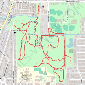
Hammock Park Trace
- Distance: 4.9 mi
- Elevation gain: 26 m
- Maximum elevation: 10 m
- Elevation loss: 28 m
- Minimum elevation: 4 m
- Moving time: 1 h 20 m
- Moving speed: 3.6 mph
- Maximum speed: 4.7 mph
- Total time: 1 h 20 m
- Global speed: 3.6 mph
Interactive trail map
Thank you for supporting this site ❤️
Make a donation
Make a donation
Gear up for your next adventure:
As an Amazon Associate, this site earns from qualifying purchases at no extra cost to you.
Trail profile
- Distance: 4.9 mi
- Elevation gain: 26 m
- Maximum elevation: 10 m
- Elevation loss: 28 m
- Minimum elevation: 4 m
- Moving time: 1 h 20 m
- Moving speed: 3.6 mph
- Maximum speed: 4.7 mph
- Total time: 1 h 20 m
- Global speed: 3.6 mph
Thank you for supporting this site ❤️
Make a donation
Make a donation
Gear up for your next adventure:
As an Amazon Associate, this site earns from qualifying purchases at no extra cost to you.
About this trail
Name: Hammock Park Trace trail, distance, elevation, map, profile, GPS track
Coordinates: 28.02879 -82.78440 28.03765 -82.77711
Thank you for supporting this site ❤️
Make a donation
Make a donation
Gear up for your next adventure:
As an Amazon Associate, this site earns from qualifying purchases at no extra cost to you.