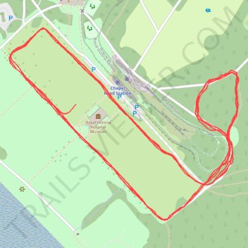
Netley Abbey Parkrun - Summer Course
- Distance: 3.1 mi
- Elevation gain: 26 m
- Maximum elevation: 16 m
- Elevation loss: 25 m
- Minimum elevation: 7 m
- Moving time: 30 m 45 s
- Moving speed: 6.1 mph
- Maximum speed: 9.5 mph
- Total time: 30 m 45 s
- Global speed: 6.1 mph
Interactive trail map
Trail profile
- Distance: 3.1 mi
- Elevation gain: 26 m
- Maximum elevation: 16 m
- Elevation loss: 25 m
- Minimum elevation: 7 m
- Moving time: 30 m 45 s
- Moving speed: 6.1 mph
- Maximum speed: 9.5 mph
- Total time: 30 m 45 s
- Global speed: 6.1 mph
About this trail
Name: Netley Abbey Parkrun - Summer Course trail, distance, elevation, map, profile, GPS track
Coordinates: 50.86486 -1.34393 50.86818 -1.33766
Topography: Hampshire topographic map, elevation, terrain