Thank you for supporting this site ❤️
Make a donation
Make a donation
Gear up for your next adventure:
As an Amazon Associate, this site earns from qualifying purchases at no extra cost to you.
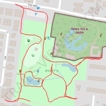
Yad LaBanim Park in Petah Tikva
- Distance: 0.9 mi
- Elevation gain: 12 m
- Maximum elevation: 54 m
- Elevation loss: 14 m
- Minimum elevation: 45 m
- Moving time: 20 m 48 s
- Moving speed: 2.7 mph
- Maximum speed: 4.0 mph
- Total time: 25 m 49 s
- Global speed: 2.1 mph
Interactive trail map
Thank you for supporting this site ❤️
Make a donation
Make a donation
Gear up for your next adventure:
As an Amazon Associate, this site earns from qualifying purchases at no extra cost to you.
Trail profile
- Distance: 0.9 mi
- Elevation gain: 12 m
- Maximum elevation: 54 m
- Elevation loss: 14 m
- Minimum elevation: 45 m
- Moving time: 20 m 48 s
- Moving speed: 2.7 mph
- Maximum speed: 4.0 mph
- Total time: 25 m 49 s
- Global speed: 2.1 mph
Thank you for supporting this site ❤️
Make a donation
Make a donation
Gear up for your next adventure:
As an Amazon Associate, this site earns from qualifying purchases at no extra cost to you.
About this trail
Name: Yad LaBanim Park in Petah Tikva trail, distance, elevation, map, profile, GPS track
Coordinates: 32.08587 34.87201 32.08812 34.87464
Thank you for supporting this site ❤️
Make a donation
Make a donation
Gear up for your next adventure:
As an Amazon Associate, this site earns from qualifying purchases at no extra cost to you.