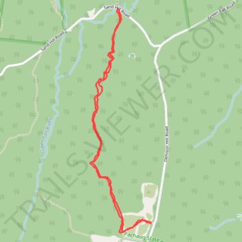
Denison Hill to Green Falls Pond
Parking area on Denison Hill Road at southern end of the route. Could park on Sand Hill Road also if you wanted to split the route. This is an unmarked trail, but is not too hard to follow. Looks like it is also used as an enduro trail, but not used often.
- Distance: 2.5 mi
- Elevation gain: 54 m
- Maximum elevation: 133 m
- Elevation loss: 54 m
- Minimum elevation: 83 m
- Moving time: 1 h 8 m
- Moving speed: 2.2 mph
- Maximum speed: 3.6 mph
- Total time: 2 h 29 m
- Global speed: 1.0 mph
Interactive trail map
Trail profile
- Distance: 2.5 mi
- Elevation gain: 54 m
- Maximum elevation: 133 m
- Elevation loss: 54 m
- Minimum elevation: 83 m
- Moving time: 1 h 8 m
- Moving speed: 2.2 mph
- Maximum speed: 3.6 mph
- Total time: 2 h 29 m
- Global speed: 1.0 mph
About this trail
Name: Denison Hill to Green Falls Pond trail, distance, elevation, map, profile, GPS track
Coordinates: 41.51091 -71.80689 41.52434 -71.80201