Make a donation
Gear up for your next adventure:
As an Amazon Associate, this site earns from qualifying purchases at no extra cost to you.
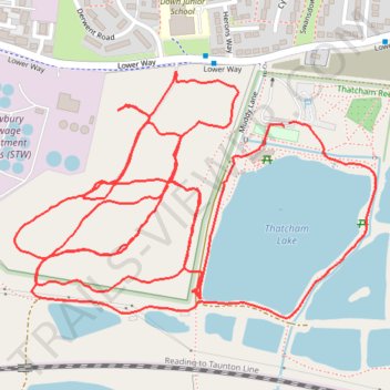
Thatcham Lake Walk
- Distance: 2.9 mi
- Elevation gain: 18 m
- Maximum elevation: 78 m
- Elevation loss: 18 m
- Minimum elevation: 69 m
- Moving time: 56 m 38 s
- Moving speed: 3.1 mph
- Maximum speed: 4.0 mph
- Total time: 57 m 59 s
- Global speed: 3.0 mph
Interactive trail map
Make a donation
Gear up for your next adventure:
As an Amazon Associate, this site earns from qualifying purchases at no extra cost to you.
Trail profile
- Distance: 2.9 mi
- Elevation gain: 18 m
- Maximum elevation: 78 m
- Elevation loss: 18 m
- Minimum elevation: 69 m
- Moving time: 56 m 38 s
- Moving speed: 3.1 mph
- Maximum speed: 4.0 mph
- Total time: 57 m 59 s
- Global speed: 3.0 mph
Make a donation
Gear up for your next adventure:
As an Amazon Associate, this site earns from qualifying purchases at no extra cost to you.
About this trail
Name: Thatcham Lake Walk trail, distance, elevation, map, profile, GPS track
Start: Muddy Lane, Thatcham, West Berkshire, England, RG19 3FU, United Kingdom (51.40044 -1.27315)
Coordinates: 51.39735 -1.28011 51.40133 -1.27080
Topography: West Berkshire topographic map, elevation, terrain
Make a donation
Gear up for your next adventure:
As an Amazon Associate, this site earns from qualifying purchases at no extra cost to you.
Other hiking, mountain biking, running and outdoor activity trails
Click on a trail to view its statistics, map and profile.
Thatcham Lake Loop Walk
United Kingdom > England > West Berkshire > Thatcham
Distance: 1.0 mi • Elevation gain: 6 m • Maximum elevation: 75 m