Make a donation
Gear up for your next adventure:
As an Amazon Associate, this site earns from qualifying purchases at no extra cost to you.
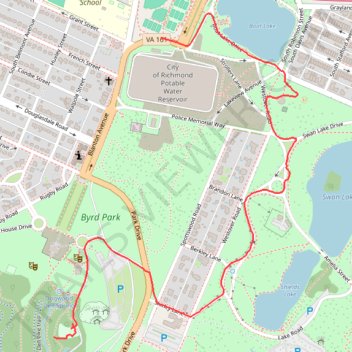
Byrd Park
- Distance: 1.6 mi
- Elevation gain: 33 m
- Maximum elevation: 72 m
- Elevation loss: 20 m
- Minimum elevation: 54 m
- Moving time: 17 m 9 s
- Moving speed: 5.5 mph
- Maximum speed: 16.5 mph
- Total time: 21 m 57 s
- Global speed: 4.3 mph
Interactive trail map
Make a donation
Gear up for your next adventure:
As an Amazon Associate, this site earns from qualifying purchases at no extra cost to you.
Trail profile
- Distance: 1.6 mi
- Elevation gain: 33 m
- Maximum elevation: 72 m
- Elevation loss: 20 m
- Minimum elevation: 54 m
- Moving time: 17 m 9 s
- Moving speed: 5.5 mph
- Maximum speed: 16.5 mph
- Total time: 21 m 57 s
- Global speed: 4.3 mph
Make a donation
Gear up for your next adventure:
As an Amazon Associate, this site earns from qualifying purchases at no extra cost to you.
About this trail
Name: Byrd Park trail, distance, elevation, map, profile, GPS track
Start: Dell Meadow, Dogwood Dell bike trail, Richmond, Virginia, 23221, United States (37.53842 -77.48345)
End: Blanton Avenue, Carillon, Richmond, Virginia, 23221, United States (37.54671 -77.47971)
Coordinates: 37.53837 -77.48345 37.54740 -77.47492
Make a donation
Gear up for your next adventure:
As an Amazon Associate, this site earns from qualifying purchases at no extra cost to you.
Other hiking, mountain biking, running and outdoor activity trails
Click on a trail to view its statistics, map and profile.
A bike ride in part to survey the new North Bank Trail section next to Hollywood
United States > Virginia > Richmond
Distance: 8.7 mi • Elevation gain: 180 m • Maximum elevation: 74 m