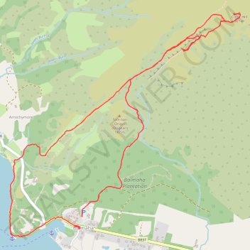
Conic Hill
- Distance: 4.2 mi
- Elevation gain: 367 m
- Maximum elevation: 351 m
- Elevation loss: 373 m
- Minimum elevation: 8 m
- Moving time: 2 h 7 m
- Moving speed: 2.0 mph
- Maximum speed: 6.5 mph
- Total time: 3 h 5 m
- Global speed: 1.4 mph
Interactive trail map
Trail profile
- Distance: 4.2 mi
- Elevation gain: 367 m
- Maximum elevation: 351 m
- Elevation loss: 373 m
- Minimum elevation: 8 m
- Moving time: 2 h 7 m
- Moving speed: 2.0 mph
- Maximum speed: 6.5 mph
- Total time: 3 h 5 m
- Global speed: 1.4 mph
About this trail
Name: Conic Hill trail, distance, elevation, map, profile, GPS track
Coordinates: 56.08361 -4.54846 56.09864 -4.52055
Topography: Stirling topographic map, elevation, terrain
Other hiking, mountain biking, running and outdoor activity trails
Click on a trail to view its statistics, map and profile.
Walking trail from Balmaha to summit of Conic Hill via West Highland Way - Slighe Taobh an Iar na Gàidhealtachd
United Kingdom > Scotland > Stirling > Balmaha > Arrochymore
Distance: 2.9 mi • Elevation gain: 318 m • Maximum elevation: 339 m