Thank you for supporting this site ❤️
Make a donation
Make a donation
Gear up for your next adventure:
As an Amazon Associate, this site earns from qualifying purchases at no extra cost to you.
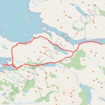
Connemara - Day 5
#Bike
- Distance: 31.3 mi
- Elevation gain: 582 m
- Maximum elevation: 76 m
- Elevation loss: 578 m
- Minimum elevation: 0 m
Interactive trail map
Thank you for supporting this site ❤️
Make a donation
Make a donation
Gear up for your next adventure:
As an Amazon Associate, this site earns from qualifying purchases at no extra cost to you.
Trail profile
- Distance: 31.3 mi
- Elevation gain: 582 m
- Maximum elevation: 76 m
- Elevation loss: 578 m
- Minimum elevation: 0 m
Thank you for supporting this site ❤️
Make a donation
Make a donation
Gear up for your next adventure:
As an Amazon Associate, this site earns from qualifying purchases at no extra cost to you.
About this trail
Name: Connemara - Day 5 trail, distance, elevation, map, profile, GPS track
Coordinates: 53.55305 -9.98560 53.60901 -9.70525
Thank you for supporting this site ❤️
Make a donation
Make a donation
Gear up for your next adventure:
As an Amazon Associate, this site earns from qualifying purchases at no extra cost to you.
Other hiking, mountain biking, running and outdoor activity trails
Click on a trail to view its statistics, map and profile.
Connemara - Day 1
Ireland > County Galway > Leenaun
#Bike
Distance: 38.6 mi • Elevation gain: 651 m • Maximum elevation: 76 m
Connemara - Day 4
#Bike
Distance: 44.8 mi • Elevation gain: 662 m • Maximum elevation: 96 m