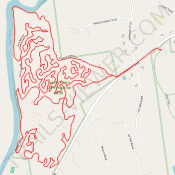
Fields Farms Conservation Area Trails
- Distance: 6.9 mi
- Elevation gain: 126 m
- Maximum elevation: 100 m
- Elevation loss: 126 m
- Minimum elevation: 62 m
- Moving time: 1 h 9 m
- Moving speed: 5.9 mph
- Maximum speed: 16.0 mph
- Total time: 1 h 19 m
- Global speed: 5.2 mph
Interactive trail map
Trail profile
- Distance: 6.9 mi
- Elevation gain: 126 m
- Maximum elevation: 100 m
- Elevation loss: 126 m
- Minimum elevation: 62 m
- Moving time: 1 h 9 m
- Moving speed: 5.9 mph
- Maximum speed: 16.0 mph
- Total time: 1 h 19 m
- Global speed: 5.2 mph
About this trail
Name: Fields Farms Conservation Area Trails trail, distance, elevation, map, profile, GPS track
Coordinates: 42.83906 -71.55864 42.84794 -71.54742
Other hiking, mountain biking, running and outdoor activity trails
Click on a trail to view its statistics, map and profile.
Fields Farm Conservation Area Trails
United States > New Hampshire > Hillsborough County > Merrimack
Distance: 1.6 mi • Elevation gain: 33 m • Maximum elevation: 97 m