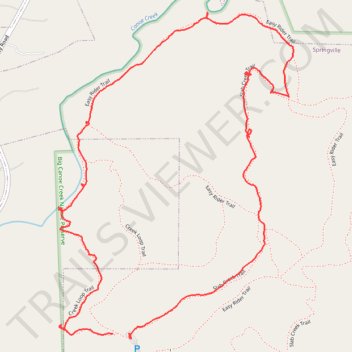
Big Canoe Creek Nature Preserve Loop Walk
- Distance: 2.7 mi
- Elevation gain: 78 m
- Maximum elevation: 269 m
- Elevation loss: 82 m
- Minimum elevation: 202 m
- Moving time: 1 h 16 m
- Moving speed: 2.1 mph
- Maximum speed: 3.8 mph
- Total time: 1 h 48 m
- Global speed: 1.5 mph
Interactive trail map
Trail profile
- Distance: 2.7 mi
- Elevation gain: 78 m
- Maximum elevation: 269 m
- Elevation loss: 82 m
- Minimum elevation: 202 m
- Moving time: 1 h 16 m
- Moving speed: 2.1 mph
- Maximum speed: 3.8 mph
- Total time: 1 h 48 m
- Global speed: 1.5 mph
About this trail
Name: Big Canoe Creek Nature Preserve Loop Walk trail, distance, elevation, map, profile, GPS track
Start: Creek Loop Trail, Springville, St. Clair County, Alabama, 35146, United States (33.79605 -86.48353)
End: Slab Creek Trail, Springville, St. Clair County, Alabama, 35146, United States (33.79592 -86.48282)
Coordinates: 33.79590 -86.48558 33.80612 -86.47670
Other hiking, mountain biking, running and outdoor activity trails
Click on a trail to view its statistics, map and profile.
Big Canoe Creek Nature Preserve Loop Trail
United States > Alabama > St. Clair County > Springville
Distance: 4.6 mi • Elevation gain: 208 m • Maximum elevation: 303 m
Big Canoe Creek Nature Preserve
United States > Alabama > St. Clair County > Springville
Distance: 1.7 mi • Elevation gain: 67 m • Maximum elevation: 269 m