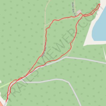
Miller Bay Trail
- Distance: 0.7 mi
- Elevation gain: 31 m
- Maximum elevation: 26 m
- Elevation loss: 32 m
- Minimum elevation: 4 m
- Moving time: 12 m 58 s
- Moving speed: 3.0 mph
- Maximum speed: 7.4 mph
- Total time: 18 m 4 s
- Global speed: 2.2 mph
Interactive trail map
Trail profile
- Distance: 0.7 mi
- Elevation gain: 31 m
- Maximum elevation: 26 m
- Elevation loss: 32 m
- Minimum elevation: 4 m
- Moving time: 12 m 58 s
- Moving speed: 3.0 mph
- Maximum speed: 7.4 mph
- Total time: 18 m 4 s
- Global speed: 2.2 mph
About this trail
Name: Miller Bay Trail trail, distance, elevation, map, profile, GPS track
Coordinates: 54.26287 -130.26939 54.26589 -130.26442
Other hiking, mountain biking, running and outdoor activity trails
Click on a trail to view its statistics, map and profile.