Thank you for supporting this site ❤️
Make a donation
Make a donation
Gear up for your next adventure:
As an Amazon Associate, this site earns from qualifying purchases at no extra cost to you.
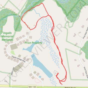
Boxford Price Property
- Distance: 1.5 mi
- Elevation gain: 21 m
- Maximum elevation: 41 m
- Elevation loss: 20 m
- Minimum elevation: 32 m
- Moving time: 33 m 45 s
- Moving speed: 2.7 mph
- Maximum speed: 12.2 mph
- Total time: 35 m 41 s
- Global speed: 2.6 mph
Interactive trail map
Thank you for supporting this site ❤️
Make a donation
Make a donation
Gear up for your next adventure:
As an Amazon Associate, this site earns from qualifying purchases at no extra cost to you.
Trail profile
- Distance: 1.5 mi
- Elevation gain: 21 m
- Maximum elevation: 41 m
- Elevation loss: 20 m
- Minimum elevation: 32 m
- Moving time: 33 m 45 s
- Moving speed: 2.7 mph
- Maximum speed: 12.2 mph
- Total time: 35 m 41 s
- Global speed: 2.6 mph
Thank you for supporting this site ❤️
Make a donation
Make a donation
Gear up for your next adventure:
As an Amazon Associate, this site earns from qualifying purchases at no extra cost to you.
About this trail
Name: Boxford Price Property trail, distance, elevation, map, profile, GPS track
Coordinates: 42.71208 -71.04054 42.71887 -71.03542
Thank you for supporting this site ❤️
Make a donation
Make a donation
Gear up for your next adventure:
As an Amazon Associate, this site earns from qualifying purchases at no extra cost to you.