Make a donation
Gear up for your next adventure:
As an Amazon Associate, this site earns from qualifying purchases at no extra cost to you.
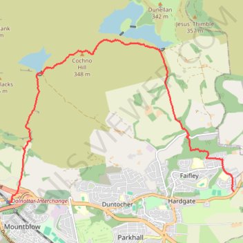
Jaw Reservoir, Cochno Hill and Greenside Reservoir in Kilpatrick Hills
- Distance: 5.9 mi
- Elevation gain: 276 m
- Maximum elevation: 342 m
- Elevation loss: 339 m
- Minimum elevation: 29 m
- Moving time: 2 h 8 m
- Moving speed: 2.8 mph
- Maximum speed: 5.0 mph
- Total time: 2 h 11 m
- Global speed: 2.7 mph
Interactive trail map
Make a donation
Gear up for your next adventure:
As an Amazon Associate, this site earns from qualifying purchases at no extra cost to you.
Trail profile
- Distance: 5.9 mi
- Elevation gain: 276 m
- Maximum elevation: 342 m
- Elevation loss: 339 m
- Minimum elevation: 29 m
- Moving time: 2 h 8 m
- Moving speed: 2.8 mph
- Maximum speed: 5.0 mph
- Total time: 2 h 11 m
- Global speed: 2.7 mph
Make a donation
Gear up for your next adventure:
As an Amazon Associate, this site earns from qualifying purchases at no extra cost to you.
About this trail
Name: Jaw Reservoir, Cochno Hill and Greenside Reservoir in Kilpatrick Hills trail, distance, elevation, map, profile, GPS track
Coordinates: 55.92394 -4.45252 55.95158 -4.38443
Topography: West Dunbartonshire topographic map, elevation, terrain
Make a donation
Gear up for your next adventure:
As an Amazon Associate, this site earns from qualifying purchases at no extra cost to you.
Other hiking, mountain biking, running and outdoor activity trails
Click on a trail to view its statistics, map and profile.
The Slacks Loop Trail in Kilpatrick Hills
United Kingdom > Scotland > West Dunbartonshire > Old Kilpatrick
Distance: 5.4 mi • Elevation gain: 354 m • Maximum elevation: 359 m
Cochno Loch and Hill - Kilpatrick Hills
United Kingdom > Scotland > West Dunbartonshire > Faifley > Cochno
Distance: 3.9 mi • Elevation gain: 205 m • Maximum elevation: 332 m