Make a donation
Gear up for your next adventure:
As an Amazon Associate, this site earns from qualifying purchases at no extra cost to you.
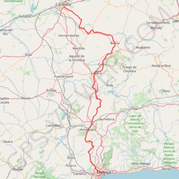
Málaga - Córdoba
One-way between Málaga and Córdoba.
- Distance: 140.8 mi
- Elevation gain: 4,872 m
- Maximum elevation: 979 m
- Elevation loss: 4,790 m
- Minimum elevation: 10 m
Interactive trail map
Make a donation
Gear up for your next adventure:
As an Amazon Associate, this site earns from qualifying purchases at no extra cost to you.
Trail profile
- Distance: 140.8 mi
- Elevation gain: 4,872 m
- Maximum elevation: 979 m
- Elevation loss: 4,790 m
- Minimum elevation: 10 m
Make a donation
Gear up for your next adventure:
As an Amazon Associate, this site earns from qualifying purchases at no extra cost to you.
About this trail
Name: Málaga - Córdoba trail, distance, elevation, map, profile, GPS track
Coordinates: 36.72071 -4.77069 37.86813 -4.32230
Make a donation
Gear up for your next adventure:
As an Amazon Associate, this site earns from qualifying purchases at no extra cost to you.
Other hiking, mountain biking, running and outdoor activity trails
Click on a trail to view its statistics, map and profile.
Southern section — European Divide Trail
France > Auvergne-Rhône-Alpes > Drôme > Valence
Distance: 1,506.1 mi • Elevation gain: 42,375 m • Maximum elevation: 2,005 m
1 LUCENA - MONTPELLIER
Distance: 1,842.0 mi • Elevation gain: 29,500 m • Maximum elevation: 1,048 m