Thank you for supporting this site ❤️
Make a donation
Make a donation
Gear up for your next adventure:
As an Amazon Associate, this site earns from qualifying purchases at no extra cost to you.
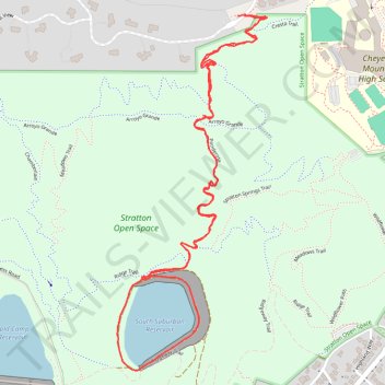
South Suburban Reservoir Loop via Ponderosa in Stratton Open Space
405
- Distance: 2.7 mi
- Elevation gain: 87 m
- Maximum elevation: 1,988 m
- Elevation loss: 85 m
- Minimum elevation: 1,936 m
- Moving time: 52 m 2 s
- Moving speed: 3.1 mph
- Maximum speed: 4.6 mph
- Total time: 56 m 57 s
- Global speed: 2.9 mph
Interactive trail map
Thank you for supporting this site ❤️
Make a donation
Make a donation
Gear up for your next adventure:
As an Amazon Associate, this site earns from qualifying purchases at no extra cost to you.
Trail profile
- Distance: 2.7 mi
- Elevation gain: 87 m
- Maximum elevation: 1,988 m
- Elevation loss: 85 m
- Minimum elevation: 1,936 m
- Moving time: 52 m 2 s
- Moving speed: 3.1 mph
- Maximum speed: 4.6 mph
- Total time: 56 m 57 s
- Global speed: 2.9 mph
Thank you for supporting this site ❤️
Make a donation
Make a donation
Gear up for your next adventure:
As an Amazon Associate, this site earns from qualifying purchases at no extra cost to you.
About this trail
Name: South Suburban Reservoir Loop via Ponderosa in Stratton Open Space trail, distance, elevation, map, profile, GPS track
Coordinates: 38.79410 -104.86706 38.80451 -104.86142
Thank you for supporting this site ❤️
Make a donation
Make a donation
Gear up for your next adventure:
As an Amazon Associate, this site earns from qualifying purchases at no extra cost to you.