Thank you for supporting this site ❤️
Make a donation
Make a donation
Gear up for your next adventure:
As an Amazon Associate, this site earns from qualifying purchases at no extra cost to you.
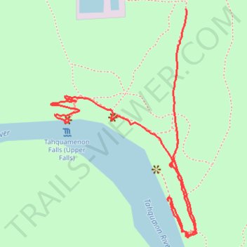
Upper Tahquamenon Falls trail
- Distance: 1.1 mi
- Elevation gain: 66 m
- Maximum elevation: 241 m
- Elevation loss: 36 m
- Minimum elevation: 206 m
- Moving time: 26 m 24 s
- Moving speed: 2.5 mph
- Maximum speed: 4.3 mph
- Total time: 32 m 33 s
- Global speed: 2.1 mph
Interactive trail map
Thank you for supporting this site ❤️
Make a donation
Make a donation
Gear up for your next adventure:
As an Amazon Associate, this site earns from qualifying purchases at no extra cost to you.
Trail profile
- Distance: 1.1 mi
- Elevation gain: 66 m
- Maximum elevation: 241 m
- Elevation loss: 36 m
- Minimum elevation: 206 m
- Moving time: 26 m 24 s
- Moving speed: 2.5 mph
- Maximum speed: 4.3 mph
- Total time: 32 m 33 s
- Global speed: 2.1 mph
Thank you for supporting this site ❤️
Make a donation
Make a donation
Gear up for your next adventure:
As an Amazon Associate, this site earns from qualifying purchases at no extra cost to you.
About this trail
Name: Upper Tahquamenon Falls trail trail, distance, elevation, map, profile, GPS track
Start: North Country Trail, McMillan Township, Luce County, Michigan, United States (46.57503 -85.25682)
End: North Country Trail, McMillan Township, Luce County, Michigan, United States (46.57754 -85.25296)
Coordinates: 46.57249 -85.25731 46.57754 -85.25261
Thank you for supporting this site ❤️
Make a donation
Make a donation
Gear up for your next adventure:
As an Amazon Associate, this site earns from qualifying purchases at no extra cost to you.